
![]()
|
|
|
Zuletzt aktualisiert am: 13.04.16
|
Wandergebiet: England
Weitwanderwege (alphabetisch)
Regions (Counties) Southwest England (SW): (Cornwall, Devon, Dorset, Somerset, Gloucester, Wiltshire) Southern England (S): (Hampshire, Isle of Wight, Sussex, Kent, Surrey, Berkshire, Buckingham, Oxford) Eastern England (E): (Hertford, Cambridge, Essex, Norfolk, Suffolk) East Midlands (E Mids): (Northampton, Leicester, Rutland, Derby, Nottingham, Lincoln) West Midlands (W Mids): (Hereford, Worcester, Warwick, Birmingham, Stafford, Shropshire) Northwest England (NW): (Cheshire, Manchester, Liverpool, Lancashire) Northeast England (NE): (Northumbria, Durham, Newcastle, Cleveland, Teesside)
Gebiets-Referenzperson
im Netzwerk Weitwandern e.V. Herr Walter Brückner Kontakt über: Webmaster
Betreuende Wanderverbände
Alpine Vereine: British Mountaineering Council
Unterkunftsverzeichnisse Englischer Jugendherbergsverband: Youth Hostels Association
Naturfreunde International: Naturefriends - Great Britain
Fremdenverkehrsamt in Deutschland: Britische Zentrale für Fremdenverkehr
Fremdenverkehrsverbände der Regionen: Übersicht South East of England (East Sussex, West Sussex, Surrey, Kent)
Diverse Unterkunftsverzeichnisse
Tourismus-Info's (siehe auch "Fremdenverkehrsverbände der Regionen")
Bahn
und Bus
Landkarten - Wanderführer - Literatur Landesvermessungsbehörde: Ordnance Survey
Diverse Landkarten: Großbritannien
Wanderführer: Europa
Diverse Bezugsquellen: in Deutschland
Weitwanderwege-Service
Basis-Info's
Wanderberichte Wanderberichte - Großbritannien
Kritik und Mitteilungen
Europäische Fernwanderwege im Wandergebiet
Kurzbeschreibungen "Österreichischen Alpenverein, Sektion Weitwanderer"
Übersichtskarten Übersichtskarte der Europäischen Fernwanderwege
E2 England - Nordsee - Vogesen - Genfer See - Westalpen - Riviera E2 Stranraer (SL) - Harwich (S) or Dover (E) 1400 km Beschreibung: E2
E8 Irland - England - Nordsee - Rhein - Main - Donau - Karpaten - Rila - Rhodopen E8 Liverpool (Y) - Hull (E Mids) 300 km Beschreibung: Trans Pennine Trail
E9 "Internationaler Küstenweg" Atlantik - Nordsee - Ostsee E9 Plymouth (SW) - Dover (E) 705 km Beschreibung: E9
Weitwanderwege 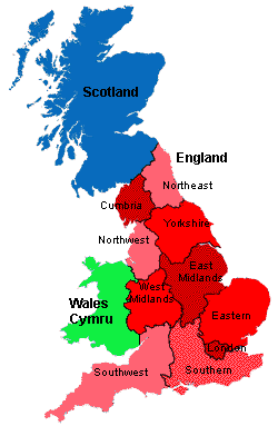
----------------------
Weitwanderwege in Southwest England (SW)
Cotswold Round: Circular via Bath (SW) and Chipping Campden (SW) 331 km Beschreibung: Cotswold Round (LDWA)
Cotswold Way: Chipping Campden (W Mids) - Bath (SW) 163 km Beschreibung: Cotswold Way (LDWA)
Cross-Cotswold Pathway: Bath (SW) - Banbury (S) 138 km Beschreibung: Cross-Cotswold Pathway (LDWA)
D'Arcy Dalton Way: Wormleighton (W Mids) - Waylands Smithy (S) 106 km Beschreibung: D'Arcy Dalton Way (LDWA)
From the Wye to the Thames: Hereford (S) - Oxford (W Mids) 192 km Beschreibung: Wye to the Thames (LDWA)
Greater Ridgeway: Lyme Regis (SW) - Hunstanton (E) 583 km Beschreibung: Ridgeway National Trail (LDWA)
Heart of England Way (E2): Milford bei Stafford (W Mids) - Bourton-on-the-Water (SW) 161 km Beschreibung: Heart of England Way (LDWA)
Jubilee Trail: Forde Abbey (SW) - Bokerley Dyke (SW) 145 km Beschreibung: Jubilee Trail (LDWA)
Macmillan Way (main route): Boston (W Mids) - Abbotsbury (S) 467 km
Beschreibung:
Macmillan
Way (LDWA)
Macmillan Way West: Castle Cary (SW) - Barnstaple (SW) 160 km Beschreibung: Macmillan Way (LDWA)
Monarch's Way: Worcester (W Mids) - Shoreham (S) 982 km Beschreibung: Monarch's Way (LDWA)
North Cotswold Diamond Way: cirular from Moreton-in-Marsh (SW) 96 km Beschreibung: North Cotswold Diamond Way (LDWA)
Offa's Dyke Path: Chepstow (W) - Prestatyn (W) 283 km Beschreibung: Offa's Dyke Path (LDWA) Wanderführer: Wales: Offa's Dyke Path
Oxfordshire Way (E2): Bourton-on-the-Water (S) - Henley (SW) 105 km Beschreibung: Oxfordshire Way (LDWA)
Ridgeway National Trail: Overton Hill (S) - Ivinghoe (E) 137 km Beschreibung: Ridgeway (LDWA)
Severn Way: Plynlimon (W) - Bristol (SW) 360 km Beschreibung: Severn Way (LDWA)
Solent Way: Christchurch (SW) - Emsworth (S) 112 km Beschreibung: Solent Way (LDWA)
South West Coast Path (E9): Minehead (SW) - Poole (S) 1014 km Beschreibung: South West Coast Path (LDWA)
Tarka Trail: 2 circles from Barnstaple (SW) 288 km Beschreibung: Tarka Trail (LDWA)
Thames Path: Thames Head (SW) - Thames Barrier (S) 294 km Beschreibung: Thames Path (LDWA) Wanderführer: England: Themse-Ring
Two Moors Way: Ivybridge - Lynmouth 166 km Beschreibung: Two Moors Way (LDWA)
Wessex Ridgeway: Marlborough (S) - Lyme Regis (SW) 219 km Beschreibung: Wessex Ridgeway (LDWA)
Wye Valley Walk: Chepstow (W) - Plynlimon (W) 218 km Beschreibung: Wye Valley Walk (LDWA)
Weitwanderwege in Southern England (S)
Chiltern Way: curcular from Hemel Hempstead (S) 275 km Beschreibung: Chiltern Way (LDWA)
Cotswold Round: Circular via Bath (SW) and Chipping Campden (SW) 331 km Beschreibung: Cotswold Round (LDWA)
Cross-Cotswold Pathway: Bath (SW) - Banbury (S) 138 km Beschreibung: Cross-Cotswold Pathway (LDWA)
D'Arcy Dalton Way: Wormleighton (W Mids) - Waylands Smithy (S) 106 km Beschreibung: D'arcy Dalton Way (LDWA)
From the Wye to the Thames: Hereford (S) - Oxford (W Mids) 192 km Beschreibung: Wye to the Thames (LDWA)
Grand Union Canal Walk: Paddington or Brentford (L) - Birmingham (W Mids) 234 km Beschreibung: Grand Union Canal Walk (LDWA)
Greater Ridgeway: Lyme Regis (SW) - Hunstanton (E) 583 km Beschreibung: Ridgeway National Trail (LDWA)
Greensand Way: Haslemere (S) - Hamstreet (S) 169 km Beschreibung: Greensand Way (LDWA)
Icknield Way Path (E2): Bledlow (E) - Knettishall Heath (S) 206 km Beschreibung: Icknield Way Path (LDWA)
Jurassic Way: Banbury (S) - Stamford (E) 583 km Beschreibung: Jurassic Way (LDWA)
Macmillan Way (main route): Boston (W Mids) - Abbotsbury (S) 467 km
Beschreibung:
Macmillan
Way (LDWA)
Midshires Way: Princes Risborough (L) - Stockport (NW) 363 km Beschreibung: Midshires Way (LDWA)
Monarch's Way: Worcester (W Mids) - Shoreham (S) 982 km Beschreibung: Monarch's Way (LDWA)
North Downs Way (E2): Farnham (S) - Dover (S) 227 km
Beschreibung:
North
Downs Way (LDWA)
Oxford Canal Walk (E2): Oxford (S) - Coventry (W Mids) 132 km Beschreibung: Oxford Canal Walk (LDWA)
Oxfordshire Way (E2): Bourton-on-the-Water (S) - Henley on Thames (S) 105 km Beschreibung: Oxfordshire Way (LDWA)
Ridgeway National Trail: Overton Hill (S) - Ivinghoe (E) 137 km Beschreibung: Ridgeway (LDWA)
Saxon Shore Way:Gravesend (S) - Hastings (S) 261 km Beschreibung: Saxon Shore Way (LDWA)
Solent Way: Christchurch (SW) - Emsworth (S) 112 km Beschreibung: Solent Way (LDWA)
South Downs Way: Eastbourne (S) - Winchester (S) 161 km Beschreibung: South Downs Way (LDWA)
Swan's Way: Salcey Forest (S) - Bledlow (E Mids) 104 km Beschreibung: Swan's Way (LDWA)
Thames Path: Thames Head (SW) - Thames Barrier (S) 294 km Beschreibung: Thames Path (LDWA) Wanderführer: Wales: Themse-Ring
Three Castles Path: Windsor (S) - Winchester (S) 96 km Beschreibung: Three Castles Path (LDWA)
Vanguard Way: Croydon (S) - Newhaven (S) 107 km Beschreibung: Vanguard Way (LDWA)
Wealdway: Gravesend (S) - Eastbourne (S) 129 km
Beschreibung:
Wealdway
(LDWA)
Weitwanderwege in Greater London (L)
Bromley Circular Walks: North Downs near Berry's Green (L) 177 km Beschreibung: Bromley Circular Walks (LDWA)
Capital Ring: Circular via Woolwich and Richmond (L) 115 km Beschreibung: Capital Ring (LDWA)
Epping Forest Centenary Walk: Manor Park (L) - Epping (L) 24 km connecting with Essex Way: Epping (L) - Harwich (E) 130 km Beschreibung: Essex Way (LDWA
Grand Union Canal Walk: Paddington or Brentford (L) - Birmingham (W Mids) 234 km Beschreibung: Grand Union Canal Walk (LDWA)
Hertfordshire Chain Walk: Crews Hill (E) - Ashwell (L) & back 140 km Beschreibung: Hertfordshire Chain Walk (LDWA)
London Loop: Erith (S) - Rainham (E), around Greater London 241 km Beschreibung: London Loop (LDWA)
North Downs Way (E2): Farnham (S) - Dover (S) 246 km Beschreibung: North Downs Way (LDWA)
Thames Path: Thames Head (SW) - Thames Barrier (S) 294 km Beschreibung: Thames Path (LDWA) Wanderführer: Wales: Themse-Ring
Three Forests Way: Circular via Hatfield, Hainault and Epping Forests 96 km Beschreibung: Three Forests Way (LDWA)
Vanguard Way: Croydon (S) - Newhaven (S) 107 km Beschreibung: Vanguard Way (LDWA)
Weitwanderwege in Eastern England (E)
Angles Way: Great Yarmouth (E) - Knettishall Heath (E) 124 km Beschreibung: Angles Way (LDWA)
Chiltern Way: circular from Hemel Hempstead (S) 275 km Beschreibung: Chiltern Way (LDWA)
Essex Way (E2): Epping (E) - Harwich (E) 130 km Beschreibung: Essex Way (LDWA)
Fen Rivers Way: Cambridge (E) - Ongar Hill near King's Lynn (E) 98,5 km Beschreibung: Fen Rivers Way (LDWA)
Greater Ridgeway: Lyme Regis (SW) - Hunstanton (E) 583 km Beschreibung: Ridgeway National Trail (LDWA)
Hereward Way: Oakham (E Mids) - Harling Rd Stn, Norfolk (E) 166 km Beschreibung: Hereward Way (LDWA)
Hertfordshire Chain Walk: Crews Hill (E) - Ashwell (L) & back 140 km Beschreibung: Hertfordshire Chain Walk (LDWA)
Hertfordshire Way: Circular von Hertford (E) via Royston und St. Albans 266 km
Beschreibung:
Hertfordshire
Way (LDWA)
Icknield Way Path (E2): Bledlow (E) - Knettishall Heath (S) 206 km Beschreibung: Icknield Way Path (LDWA)
London Loop: Erith (S) - Rainham (E), around Greater London 241 km Beschreibung: London Loop (LDWA)
Nene Way: Badby (E) - Sutton Bridge (E Mids) 177 km Beschreibung: Nene Way (LDWA)
Oxford Canal Walk (E2): Oxford (S) - Coventry (W Mids) 132 km Beschreibung: Oxford Canal Walk (LDWA
Peddars Way & Norfolk Coast Path: Knettishall (E) - Cromer (E) 149 km Beschreibung: Peddars Way(LDWA)
Ridgeway National Trail: Overton Hill (S) - Ivinghoe (E) 137 km Beschreibung: Ridgeway (LDWA)
Sandlings Walk: Ipswich (E) - Southwold (E) 96 km Beschreibung: SandlingsWalk (LDWA)
Stour Valley Path (E Anglia) (E2): Newmarket (E) - Manningtree (E) 96 km Beschreibung: Stour Valley Path (LDWA)
Suffolk Coast & Heaths Path: Manningtree (E) - Lowestoft (E) 106 km Beschreibung: Suffolk Coast & Heaths Path (LDWA)
Three Forests Way: Circular via Hatfield, Hainault and Epping Forests 96 km Beschreibung: Three Forests Way (LDWA)
Weitwanderwege in East Midlands (E Mids)
Grand Union Canal Walk: Paddington or Brentford (L) - Birmingham (W Mids) 234 km Beschreibung: Grand Union Canal Walk (LDWA)
Hereward Way: Oakham (E Mids) - Harling Rd Stn, Norfolk (E) 166 km Beschreibung: Hereward Way (LDWA)
Jurassic Way: Banbury (S) - Stamford (E) 583 km Beschreibung: Jurassic Way (LDWA)
Macmillan Way (main route): Boston (W Mids) - Abbotsbury (S) 464 km Beschreibung: Macmillan Way (LDWA)
Midshires Way: Princes Risborough (L) - Stockport (NW) 363 km Beschreibung: Midshires Way (LDWA)
Nene Way: Badby (E) - Sutton Bridge (E Mids) 177 km Beschreibung: Nene Way (LDWA)
Oxford Canal Walk (E2): Oxford (S) - Coventry (W Mids) 132 km Beschreibung: Oxford Canal Walk (LDWA)
Pennine Bridleway: Carsington Reservoir or Middleton Top (E) - Byrness (SL) 560 km Beschreibung: Pennine Bridleway (LDWA)
Pennine Way (E2): Edale (E Mids) - Kirk Yetholm (SL) 429 km Beschreibung: Pennine Way (LDWA) Wanderführer: England: Pennine Way
Robin Hood Way: Nottingham (E Mids) - Edwinstone (E Mids) 165 km Beschreibung: Robin Hood Way (LDWA)
Rutland Round: Circular from Oakham (105 km) Beschreibung: Rutland Round (LDWA)
Staffordshire Way (E2): Mow Cop (W Mids) - Kinver Edge (E Mids) 147 km Beschreibung: Staffordshire Way (LDWA)
Swan's Way: Salcey Forest (S) - Bledlow (E Mids) 104 km Beschreibung: Swan's Way (LDWA)
Trans Pennine Trail: Southport (NW) - Hornsea (Y) 322 km Beschreibung: Trans Pennine Trail (LDWA)
Trent and Mersey Canal Walk: Preston Breek, Runcorn (E Mids) - Froghall or Long Eaton ((W Mids) 177 km Beschreibung: Trent and Mersey Canal (LDWA)
Viking Way (E2): Barton-upon-Humber (E Mids) - Oakham (E Mids) 225 km Beschreibung: Viking Way (LDWA)
White Peak Way: Circular from Bakewell (E Mids) 130 km Beschreibung: White Peak Way (LDWA)
Weitwanderwege
in West Midlands (W Mids)
Birmingham and Aberystwyth Walk: Birmingham (W Mids) - Aberystwyth (W) 240 km Beschreibung: Birmingham and Aberystwyth Walk (LDWA)
Birmingham Canal Navigations: Various destinations around Birmingham (W Mids) 160 km Beschreibung:
Centenary Way (Warwickshire): Kingsbury Water Park (W Mids) - Upper Quinton (W Mids) 158 km Beschreibung: Centenary Way (Warwickshire) (LDWA)
Cheshire Ring Canal Walk: Circular from Marple (W Mids) 155 km Beschreibung: Cheshire Ring Canal Walk (LDWA)
Cotswold Round: Circular via Bath (SW) and Chipping Camden (SW) 331 km Beschreibung: Cotswold Round (LDWA)
Cotswold Way: Chipping Camden (W Mids) - Bath (SW) 161 km Beschreibung: Cotswold Way (LDWA)
D'Arcy Dalton Way: Wormleighton (W Mids) - Waylands Smithy (S) 106 km Beschreibung: D'arcy Dalton Way (LDWA)
Elan Valley Way: Birmingham (W Mids) - Elan (W) 205 km Beschreibung: Elan Valley Way (LDWA)
From the Wye to the Thames: Hereford (S) - Oxford (W Mids) 192 km
Beschreibung:
Wye to the Thames (LDWA)
Grand Union Canal Walk: Paddington or Brentford (L) - Birmingham (W Mids) 234 km Beschreibung: Grand Union Canal Walk (LDWA)
Heart of England Way (E2): Milford near Stafford(W Mids) - Bourton-on-the-Water (SW) 161 km Beschreibung: Heart of England Way (LDWA)
Macmillan Way (main route): Boston (W Mids) - Abbotsbury (S) 464 km Beschreibung: Macmillan Way (LDWA)
Monarch's Way: Worcester (W Mids) - Shoremham (S) 982 km Beschreibung: Monarch's Way (LDWA)
Navigation Way: Birmingham (W Mids) - Lapworth - Dudley - Wolverhampton - Kinver - Chasewater 160 km Beschreibung: Navigation Way (LDWA)
Offa's Dyke Path: Chepstow (W) - Prestatyn (W) 283 km Beschreibung: Offa's Dyke Path (LDWA) Wanderführer: Wales: Offa's Dyke Path
Oxford Canal Walk (E2): Oxford (S) - Coventry (W Mids) 132 km Beschreibung: Oxford Canal Way (LDWA Wanderführer: Wales: Offa's Dyke Path
Severn Way: Plynlimon (W) - Bristol (SW) 360 km Beschreibung: Severn Way (LDWA)
Shropshire Union Canal: Ellesmere Port (W Mids) - Newton, LLantysilio, Wolverhampton or Middelwich (W Mids) 251 km Beschreibung: Shropshire Union Canal (LDWA)
Shropshire Way: Circular von Wem (W Mids) 201 km Beschreibung: Shropshire Way (LDWA)
Staffordshire Way (E2): Mow Cop (W Mids) - Kinver Edge (E Mids) 147 km Beschreibung: Staffordshire Way (LDWA)
Trent and Mersey Canal Walk: Preston Breek, Runcorn (E Mids) - Froghall or Long Eaton ((W Mids) 177 km Beschreibung: Trent and Mersey Canal (LDWA)
Wye Valley Walk: Chepstow (W) - Plynlimon (W) 218 km Beschreibung: Wye Valley Walk (LDWA)
Weitwanderwege in Northwest (NW)
Cheshire Ring Canal Walk: Circular from Marple (W Mids) 155 km Beschreibung: Cheshire Ring Canal Walk (LDWA)
Cumbria Coastal Way: Silverdale (NW) - Gretna (SL) 240 km Beschreibung: Cumbria Coastal Way (LDWA)
Midshires Way: Princes Risborough (L) - Stockport (NW) 363 km
Beschreibung:
Midshires
Way (LDWA)
Pennine Bridleway: Carsington Reservoir or Middleton Top (E) - Byrness (SL) 560 km Beschreibung: Pennine Bridleway (LDWA)
Pennine Way (E2): Edale (E Mids) - Kirk Yetholm (SL) 429 km Beschreibung: Pennine Way (LDWA) Wanderführer: England: Pennine Way
Ribble Way: Longton (NW) - Hawes (Y) 118 km Beschreibung: Ribble Way (LDWA)
Shropshire Union Canal: Ellesmere Port (W Mids) - Newton, LLantysilio, Wolverhampton or Middelwich (W Mids) 251 km Beschreibung: Shropshire Union Canal (LDWA)
Staffordshire Way (E2): Mow Cop (W Mids) - Kinver Edge (E Mids) 147 km Beschreibung: Staffordshire Way (LDWA)
Trans Pennine Trail: Southport (NW) - Hornsea (Y) oder York (Y) 560 km Beschreibung: Trans Pennine Trail (LDWA)
Trent and Mersey Canal Walk: Preston Breek, Runcorn (E Mids) - Froghall or Long Eaton ((W Mids) 177 km Beschreibung: Trent and Mersey Canal (LDWA)
Weitwanderwege in Yorkshire (Y)
Cleveland Way (E2): Helmsley (Y) - Filey Brigg (NE) 177 km Beschreibung: Cleveland Way (LDWA) Wanderführer: England: Cleveland Way
Coast to Coast (Wainwright): St. Bees (C) - Robin Hood's Bay (Y) 294 km Beschreibung: Coast to coast (Wainwright) (LDWA)
Dales Way: Ilkley (Y) - Bowness (C) 126 km Beschreibung: Dales Way (LDWA)
Ebor Way: Helmsley (Y) - Ilkley (Y) 113 km Beschreibung: Ebor Way (LDWA)
Pennine Bridleway: Carsington Reservoir or Middleton Top (E) - Byrness (SL) 560 km Beschreibung: Pennine Bridleway (LDWA)
Pennine Way (E2): Edale (E Mids) - Kirk Yetholm (SL) 429 km Beschreibung: Pennine Way (LDWA) Wanderführer: England: Pennine Way
Ribble Way: Longton (NW) - Hawes (Y) 118 km Beschreibung: Ribble Way (LDWA)
Teesdale Way (E2): Tees Bay, Redcar (NE) - Dufton (Y) 161 km Beschreibung: Teesdale Way (LDWA)
Trans Pennine Trail: Southport (NW) - Hornsea (Y) oder York (Y) 560 km Beschreibung: Trans Pennine Trail (LDWA)
Yorkshire Wolds Way (E2): Filey (Y) - Hull (Y) 127 km Beschreibung: Yorkshire Wolds Way (LDWA)
Weitwanderwege in Northeast (NE)
Cleveland Way (E2): Helmsley (Y) - Filey Brig (NE) 177 km Beschreibung: Cleveland Way (LDWA) Wanderführer: England: Cleveland Way
Hadrian's Wall Path: Wallsend (Newcastle) (NE) - Bowness-on-Solway (C) 130 km Beschreibung: Hadrian's Wall Path (LDWA) Wanderführer: England: Hadrian's Wall Path
Pennine Bridleway: Carsington Reservoir or Middleton Top (E) - Byrness (SL) 560 km Beschreibung: Pennine Bridleway (LDWA)
Pennine Way (E2): Edale (E Mids) - Kirk Yetholm (SL) 429 km Beschreibung: Pennine Way (LDWA) Wanderführer: England: Pennine Way
St. Cuthbert's Way (E2): Lindisfarne (SL) - Melrose (NE) 100 km Beschreibung: St. Cuthbert's Way(LDWA)
Teesdale Way (E2): Tees Bay, Redcar (NE) - Dufton (Y) 161 km Beschreibung: Teesdale Way (LDWA)
Tyne Walk: Tynemouth (C) - Source near Garrigill (NE) 112 km Beschreibung:
Coast to Coast (Wainwright): St. Bees (C) - Robin Hood's Bay (Y) 304 km Beschreibung: Coast to coast (Wainwright) (LDWA)
Cumbria Coastal Way: Silverdale (NW) - Gretna (SL) 240 km Beschreibung: Cumbria Coastal Way (LDWA)
Cumbria Way: Ulverston (C) - Carlisle (C) 112 km Beschreibung: Cumbria Way (LDWA)
Dales Way: Ilkley (Y) - Bowness (C) 126 km Beschreibung: Dales Way (LDWA)
Eden Way: Rockcliffe Marsh (C) - Black Fell Moss (C) 126 km Beschreibung: Eden Way (LDWA)
Hadrian's Wall Path: Wallsend (Newcastle) (NE) - Bowness-on-Solway (C) 130 km Beschreibung: Hadrian's Wall Path (LDWA) Wanderführer: Hadrian's Wall Path
Inn Way to the Lake District: Circular via Ambleside, Boot and Broughton in Furness 144 km Beschreibung: Inn Way to the Lake District (LDWA)
Pennine Bridleway: Carsington Reservoir or Middleton Top (E) - Byrness (SL) 560 km Beschreibung: Pennine Bridleway (LDWA)
Pennine Way (E2): Edale (E Mids) - Kirk Yetholm (SL) 429 km Beschreibung: Pennine Way (LDWA) Wanderführer: England: Pennine Way
Teesdale Way (E2): Tees Bay, Redcar (NE) - Dufton (Y) 161 km Beschreibung: Teesdale Way (LDWA)
Tyne Walk: Tynemouth (C) - Source near Garrigill (NE) 112 km Beschreibung:
Weitwanderwege auf der Isle of Man (IoM)
Isle of Man Coastal Path (Raad ny Foillan): Circular from Douglas 152 km Beschreibung: Isle of Man Coastal Path (LDWA)
Weitwanderwege auf der Isle of Wight (IoW)
Isle of Wight Coast Path: Circular from Ryde 105 km Beschreibung: Isle of Wight Coast Path (LDWA
|